
 The Lakeview Area Master Plan (LAMP) will be revealed tonight, but there is one element that I think deserves special attention.
When research began on the project we were out surveying neighborhood inventory, like bike racks, streetscape environments, facade conditions, and public space. After investigating we found that Lakeview contains only .2 acres of open space per 1000 residents (The ideal ratio is 2 acres per 1000 people). This notion was reinforced during the public open houses and interview sessions when residents cried out for more public open space. So where, in a dense, developed urban neighborhood do we find available land for public space? We thought, let’s look for space on top of things and under things!
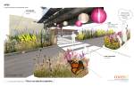
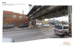
While out on a photo shoot in November we had to get from the Southport Brown line station to the Paulina station on foot. Instead of walking down to the next street we walked under the El tracks, and only after that did it occur to us that this is space we could use. The Low-Line was born. The proposed path would connect the once dissociated shopping streets of Lincoln and Southport Avenues, while increasing available open space to residents. The Low Line would feature new native landscaping, solar powered lights, semi-pervious walking surface, and above all, a space for the local community to interact away from traffic. In true urban form we have developed an efficient layering of uses, in this case two different forms of transportation. A little slice of nature in what used to be an abandoned dirtscape.
UPDATE (03/17): Check out our video recap here.
UPDATE (03/18): Blair Kamin of the Chicago Tribune says “[The] new master plan that isn’t afraid to think big or outside the box.” and has several “audacious” ideas. Cityscapes


6 comments
Comments feed for this article
March 15, 2011 at 3:17 pm
Michael
Wanting to be New York doesn’t make it so. The reason the “High Line” in New York is so successful is because there are no trains there anymore. The “low line” being under the active tracks only makes it doubly more uninviting.
Walking underneath an operable train track is the most unpleasant of experiences in this urban environment. As I said on another blog, the lack of faux-asian lanterns has nothing to do with this.
It is because there is vibration, dust, rustwater, noise — oh the noise!
There is also gravity and fear. I am the proud owner of a 4 pound 8 inch bolt that fell inches from my head one summer day walking under a CTA overpass in Lakeview.
These ideas appear inviting as silent, still snapshots – the stick figures holding hands and relaxing on park benches.
I’m waiting for the director to yell “Action” and watch the drawings come to life — throwing their fingers in their ears as the centuries old tracks clang to life in the highest decibel way only a Chicago elevated train can offer. Dirt falling from above and children yelling as metal flecks land in their eyes.
March 15, 2011 at 3:50 pm
Doug @ Beer Blog Buzz
Might be kind of cool to see a nice landscape under an old L line. Just keep the area clean and it could be very nice!
March 15, 2011 at 5:11 pm
Melissa
While Michael’s comments may provide some validity, he’s missing the main point. The intention of the “low line” is to provide connectivity between Southport Ave and Lincoln Ave, rather than creating a recreational walking/biking path. Currently, there is a disconnect between the two retail arteries and if someone wants to get from Southport to Lincoln, they have to get in their car and drive (not sustainable), walk a convoluted route, or walk under the tracks (which people already do). The plan is a great start and can provide suggestions on how to make an already used trail more aesthetically pleasing, and safer if need be.
March 16, 2011 at 3:41 pm
Vic
“Connectivity” between Southport and Lincoln? It’s already there. It’s called “Roscoe Street.” Cut it out with all the cutesy planning stuff. Chicago needs jobs that supply middle-class wages & benefits and businesses that people need and use. We don’t need more gift shops & cute restaurants.
March 16, 2011 at 9:39 am
On the fence, under the El « THE BUILT ENVIRONMENT
[…] then I stumbled upon the blog of one of the architecture firms actually doing the design work. It turns out they weren’t […]
March 26, 2011 at 4:05 pm
Alex
I don’t see why they don’t use this money better spent as a high line on the already abandoned Bloomingdale freight trail. Its the non used elevated embankment from about Ashland west to at least Central park. People all ready walk dogs/run up there. Didn’t the fright track owner already sell it to the city for a dollar, but the city doesn’t have enough park money to do anything with it?